
I have already written about the Irish Harp Society running its harp school from a house in Cromac Street for 18 years, from 1820 through to about the end of 1838.
At around the end of 1838 the harp school was moved to a new premises in Talbot Street, where it ran for over a year, until some time in 1840 when it appears to have shut for good.
This post is to try and work out where on Talbot Street the Harp Society House was, and whether we can say anything useful about it.
My header image is a 19th century photograph of the front of St Anne’s Church, looking across Donegall Street from Church Street. Talbot Street is ahead, around the corner to the right, and then down round towards the back of the church. You can look at the modern street view, but nothing in the old photo is still standing. This general area behind St Anne’s used to be known as the Half Bap, but it has now become very trendy and has been rebranded as the Cathedral Quarter (Ceathrú na hArdeaglaise).
Background
I already discussed in my post on the Harp Society House in Cromac Street how the Society’s occupancy of that house came to an end. The teacher, Valentine Rennie, died on Saturday 23 September 1837. A new teacher was recruited to replace him, though we have no records of the process. The new teacher was Alexander Jackson (sometimes called James Jackson) and he was in post probably by the beginning of 1838. Jackson initially continued to teach in the old Harp Society House in Cromac Street.
We also don’t have Harp Society records for the move from Cromac Street to Talbot street, or for the final winding up of the Society and the school. We have to work it all out from other fragmentary references.
The latest references to the Harp Society House on Cromac Street are the 1839 Sims and Mcintyres Northern or Belfast Almanac, and the 1839 Martin street directory. It is not entirely clear to me when the information may have been gathered for either of these publications. The 1839 Sims and McIntyre almanac contains a note about the Society School but does not name the teacher, and so I wonder if it may be information that was submitted late in 1837 after Rennie died, and held over for the next year’s almanac. We can be on a bit more solid ground with the Martin’s directory. This was published in Jan 1839, and so I think the information on addresses would have been gathered over the final months of 1838. So at this stage I think we can safely say that the Harp Society was still in the Cromac Street house in late 1838.
Sources
I think we have three references to the Harp Society House on Talbot Street. They come from two different sources, the Belfast Almanac published every year by Smyth, and a street directory for 1840 published by Martin.
The 1839 Smyth’s Almanac would have been published right at the end of 1838, and so the information must have been submitted late in 1838. The entry for the Harp Society reads:
Irish Harp Society – 15, Talbot Street, supported by donations, and the annual subscriptions of British and Irish gentlemen resident in India. The object is to revive the harp and music of Ireland, and to enable poor blind pupils to earn a livelihood. Mr. Jack Master. Managed by a committee. Secretary, Mr. J. M’Adam; Treasurer, Mr. Samuel Bruce. Society meet twice a year, May and November; committee more frequently.
The Belfast Almanac for the year 1839… (Belfast: Joseph Smyth) p65
We can compare this with the following year’s entry. The 1840 Smyth’s Almanac has a slightly different text, which would have been submitted right at the end of 1839. You will see that there are two differences: the address is given as no.16, instead of no.15, and the Master’s name is given as Jackson, instead of Jack. I think it is clear that the 1839 entry (above) is wrong, and the 1840 entry (below) is correct, as we will discuss later.
Irish Harp Society – 16, Talbot Street, supported by donations, and the annual subscriptions of British and Irish gentlemen resident in India. The object is to revive the Harp and music of Ireland, and to enable poor blind pupils to earn a livelihood. Mr. Jackson, Master. Managed by a committee. Secretary, Mr. J. M’Adam; Treasurer, Mr. Samuel Bruce. Society meet twice a year, May and November; committee more frequently.
The Belfast Almanac for the year of our Lord 1840… (J. Smyth) p67
The third source for the Harp Society House on Talbot Street is Martin’s street directory, which was published I think in April 1840 (the preface is dated 31 March 1840). I went to Belfast Central Library to have a look at this.
In the preface, Matthew Martin explains that he started compiling the directory in December 1839, and visited “almost every house in town” through to when he sent the completed book to the press. So we can guess that the Harp Society details were submitted some time between December 1839 and March 1840.
On p.42, under “Talbot Street”, is the entry “16 Irish Harp Society, Alexander Jackson, teacher”. On p76 in the categories section (I think of educational establishments) is the entry “Jackson, Alex., harp, Irish Harp Society, 16 Talbot-street”. And on p.153 in the alphabetical section is the entry “Jackson, Alexander, teacher of the Irish harp, 16 Talbot-street”. Also on p254 under the list of organisations is a version of the text in the Almanac, though no street address is given there.
15 or 16?
We have two different addresses for the Harp Society on Talbot Street, no.15 and no.16. We can work out what is going on in the same way as we did in Cromac Street, by making a big grid of the addresses from the street directories, to see how the numbering and occupancy changes over time.
The first thing we see is that no.15 was occupied by Miss Hainen who ran a school there, teaching English, arithmetic and needlework. She was at no.15 in the 1830s (Matier 1835) through to the 1850s (Henderson 1852). So I think that is fairly conclusive proof that the Smyth’s Almanac entry for 1839 is just a typo, and that the Harp Society was never at no.15, and that the entry should read 16.
Working out the location of no.16
My spreadsheet grid to collate the street numbers indicates that the numbering of Talbot Street at that time started on Donegall Street, and ran north-east, with the even numbers down the left (North west) side and the odd numbers down the right (south east) side. No. 2 was on the corner of Donegall Street and Talbot Street, and no. 20 was on the corner of Talbot Street and Robert Street (now Exchange Street).
Talbot Street now has nothing standing from the 19th century. The block where the Harp Society House stood is now open ground, part of the grounds of the Cathedral. But we have a very nice detailed map of the block, one of the fire insurance plans published by Charles Goad in the 1880s.

You can see that the left end of our block is numbered as houses on Donegall Street; no.2 Talbot Street is just above the first “T” of “Talbot”. You can see numbers 8 and 10 are very wide premises, a brass foundry and a “covered yard” (the buildings with large X drawn between their corners are stables). Then there is an entryway down to a large yard. The entry is given the number 14, and the yard is labelled “Commercial Hotel Stables”. The Commercial Hotel was on Waring Street, at the south end of Donegall Street, opposite the Assembly Rooms (street view). Then after the entrance to the stable yard, there is a terrace which is numbered 16 to 34, though some of the buildings are wider and cover more than one number (nos. 22-26 and 30-34).
We can collate the street directories to see how the street was re-numbered twice between 1852 and 1877.
No. 2-4 in 1880 was “Cosgrave & Bell, side door & stores”. We see on the Goad map these premises are labelled “leather wholesaler / groceries over”. I think this must correspond to no.2 in 1839-40 which seems to have been a church minister’s house.
No. 6-8 on the Goad map is workshop buildings; the Goad map labels 6 as a “mill furniture w[are]h[ou]s[e]” and no. 8 as a brass foundry. We see 6-8 occupied as a single unit in 1880 by Little & Pollock, oil & boxwood merchants, and in 1890 by Campbell, William, & Co., Brass Founders. This plot can be traced back: in 1861 it is no.4, “stores and stables” and in 1852 it is “2½. G. P. Woods’s stores and stables”. In 1850 and before this number does not appear so I am guessing this would have been open space before then.
Number 10 on the Goad map is labelled “covered yard”. In 1880 and 1890 this is occupied by “Braithwaite, Leonard, funeral undertaker & posting establishment”. They are there in 1868 but it is no.6. In 1861, no.6 is “Hugh Quinn, caravansary.” He is there also in 1852 when it is no.4. Before then, back as far as 1839, no. 4 is occupied by Hugh Tate, described either as “carman’s lodgings” or “stabling”. I would imagine “caravansary” is a fancy way of describing a yard where “car men” (i.e. wagon drivers) could park up and get accommodation – kind of the 19th century equivalent of a truck stop.
No. 12 is part of Braithwaite and Leonard’s in 1890, but in 1880 no.12 was occupied by A. McCord, French polisher, and Jonathan Fulton, wood carver. They were also there in 1877, but No. 12 does not seem to exist before then. It looks like this house may have been created at around that time by subdividing Quinn’s yard.
No. 14 on the Goud map is the entrance passage to the big yard, labelled “Commercial Hotel Stables”. There is no entry for this in 1890, but in 1880 it is listed at no.14. We can trace this yard and stables back through the street directories; in 1877 it is listed as no. 14, William Hall, yard and stables. Then in 1861 and 1868 it is again listed as Commercial Hotel Stables, but it is un-numbered, and seems to be considered as part of no.8 (the next house to the right). In 1850 and 1852 it is listed as no.6, Commercial Hotel Stables. Then before then it is listed at no.6 as another caravansary, under John Brown (1843 & 1846) and Hugh Andrews (1841-2). In 1839-40, no.6 is “Robert Havrin, provision m[erchan]t.”
No. 16 on the Goud map is the 3 storey house to the right of the passage down to the yard. In the 1880 street directory, it is listed as “Condy, Michael, ’bus driver”. In 1877 his name is “Conlon” and in 1868 his name is “Michael Connolly, omnibus driver” and he is at no.8. In 1861, no. 8 is “Sam. Patterson, omnibus driver”, to continue the theme. From 1842 to 1852 we have no.6½, occupied by Robert Cunningham, shoe maker in 1852, Hugh Fulton cabinetmaker in 1850, and William Dooey, coach driver in 1842. This premises is not listed separately before 1842, and I think it may have been considered as part of the passage and stabling yard behind.
Nos. 18 and 20 on the Goud map are two narrow three-storey houses. We don’t have any continuity of occupant over the re-numberings, but we can assume that they were re-numbered in the 1850s and again in the 1870s, from 8 to 10 to 18, and from 10 to 12 to 20.
Nos. 22, 24 and 26 on the Goud map is shown as a single building, a wide 3 storey house, and I notice that it was occupied as a single premises by one occupier right through to 1960 (when it was Dunlop footware). The Goud map labels the house and the big building behind it as “Plumber”, and we see that in 1880 it is occupied by Samuel Shannon, plumber & lead merchant. In 1868, Samuel Shannon is listed at 14, 16 & 18, confirming the renumbering of the premises after that. In 1861 14, 16 & 18 is Scully & Shannon, plumbers and lead merchants. We see Scully & Shannon at no.12 in 1852, confirming that this house was re-numbered from 12 to 14,16 & 18 between 1852 and 1861. We can see that from 1839 through to 1843 this house was occupied by William B. Allen, tallow chandler.
No.28 on the Goud map is a narrow 3 storey house. We don’t have any continuity of occupancy over the re-numbering to confirm the continuity, but it was obviously re-numbered from 14 to 20 to 28.
Nos. 30, 32 and 34 on the Goud map are show as a single premises, labelled “Timber w[are]h[ou]se. There is a dotted line to divide the building in three, and the arc signs show that this is a passage underneath. There is also a large yard behind. We see that from 1877 to 1894 this building was occupied by R. J. Carson, timber merchant. However, in 1868 we see three separate premises, no22, no.24 and no.26. Unfortunately we don’t have any continuity of occupation of any of these three over the renumberings, except that in the 1852 directory, no.20 is on the street corner, and in 1877, Carson at nos. 30, 32 & 34 is on the street corner. So I think we can be fairly confident that these three were re-numbered, from 16 to 22 to 30, from 18 to 24 to 32, and from 20 to 26 to 34. Of course it is quite possible that Carson’s premises, with the arched frontage, was newly built in about the early 70s, on the site of the three houses that it replaced. But the location is clear.
So I think we can be clear that the Harp Society House at no.16 was where the left hand section of Carson’s premises were, to the left of the archway. Carson was there until the 1920s; in the 1890s they had expanded to the left to incorporate the house at no.28. In 1901 we find J.P. Corry & Co., cement, alabaster and general fireclay goods dept. on this site. Between 1901 and 1907, Robert Street was renamed Exchange Street. We find Corry on this site through until 1943; in 1951 we see the premises occupied by Agricultural Supply (Ulster) Ltd. And in 1960, it was occupied by the Oriental Matting Co. Ltd. I think the site must have been cleared not long after that, and the entire block was incorporated into the Cathedral grounds, as we see it today behind its iron railings (street view)
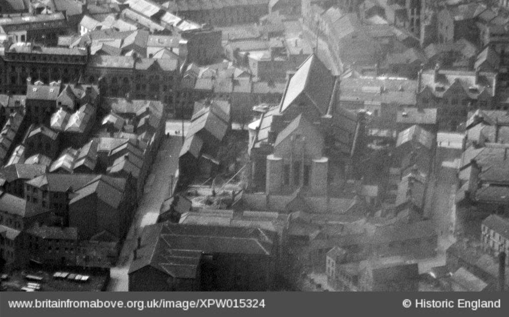
I found a couple of aerial photographs showing this area. The first is from 1926. We are looking down at the part-completed new cathedral; Donegall street runs across from left to right on the far side of the cathedral. Talbot Street runs towards us from Donegall Street to the left of the cathedral. You can see the roofs of the terrace this side of the open space, between the cathedral and Talbot street. You can see the old National School this side of the end of the cathedral. Then J.P. Corry’s premises are almost hidden, behind the taller dark building at the bottom of this crop of the photo, which is the premises on this side of Exchange Street (formerly Robert Street).
The next aerial photo is from 1950. You can see how the area on the right has been destroyed during the war in the 1940s. Our block is the corner upper left; I think the round-topped building is on what was originally the stable yard of the hotel. To the left of the trees in the cathedral grounds is the backs of our terrace; The big double roof ridge is the Agricultural Supply premises, on the corner of of Talbot Street (running left to right beyond the cathedral) and Exchange Street, formerly Robert Street, running diagonally towards us from the left edge of this crop of the photo.
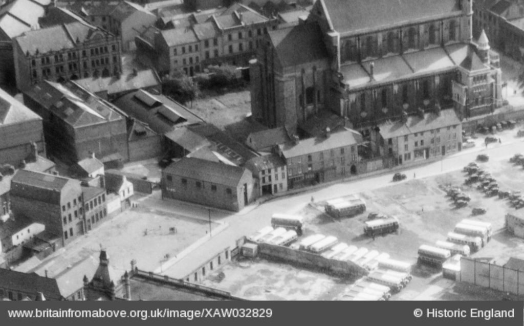
Incidentally, you can see Hugh Dornan’s house in this 1950 photo. It is the house almost entirely hidden on the centre left of the crop, with an extra-tall chimney from the point of its roof. This is the beginning of Edward Street which runs diagonally down to the left.
Talbot Street in 1839
Now that we have worked out what was where, we can start to describe more precisely how the Harp Society House fitted into the streetscape of Talbot Street in 1839-40.
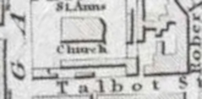
There is a map on Lennonwylie which dates from the mid 1830s. We can compare it with the 1846 OS map (on the Historical Maps Viewer at PRONI) to see that there has only been a bit of infill – the yard above the T of “Talbot” on the 1830s map has been built on by the late 1840s. Presumably this infill would be no. 2½, Woods’s stores and stables. We can also see there are constant reference points between this map and the much more detailed Goud map of 1877. We can see the entry to the stable yard above the “o” of “talbot”, and the block of buildings on the corner of Robert Street (on the right of the map, above the “t S” of “Talbot Street”). We can see the Goud map’s “covered yard” as an open space (above the “lb” of “Talbot”). The long L shaped building running between Talbot Street and the Cathedral matches the stables (marked with large Xs) on Goud’s map. And we can see the building on the corner of Talbot Street and Donegall Street at the left.
We can try to draw a little diagram showing which premises were where, in late 1839 and early 1840.

This is based on the addresses from the 1840 Martin’s street directory. I suppose my one speculation is that I’m guessing that Robert Harvin at no. 6 is the house to the right of the yard entrance, and that the building to the left of the yard entrance was part of Tate’s stables.
I think that moving from Cromac Street to Talbot street was a big step down in the world. I think Talbot street was a much poorer place, more crowded, more dirty, more noisy. A description of the rebuilding of the place on the opposite corner of Robert street in 1880 describes the houses it was replacing as “a number of dirty hovels, tenanted by habitual thieves and prostitutes”. This is presumably referring to Jane Marshall and Catherine Mallen who occupied numbers 36 and 38 on that corner in 1877.
Life in the Harp Society House
I think that everyone would have found it harder in the new Harp Society House at 16, Talbot Street, than they would have in the old Harp Society House in Cromac Street. I think it is likely that the new house was smaller and poorer, though without further information it is hard to say.
The teacher, Alexander Jackson, had been teaching students for a year or so in Cromac Street, when for whatever reason the school was moved to Talbot Street apparently right at the end of 1838.
We don’t have any Harp Society records covering this period, except for one letter written by the Secretary John McAdam, to Edward Bunting on 30th July 1839. I have already discussed this letter; it is the pessimistic letter which basically says the Gentlemen have lost interest in continuing to support the harpers, that they don’t think it is useful to preserve the inherited tradition and that they think they would be better off giving their charitable donations to a different cause. I wonder if the inferior new premises were more depressing and helped the Gentlemen to come to this conclusion?
But we can also use McAdam’s letter to try and work out what was going on in the Harp Society House at that time. He writes:
…the funds will be exhausted about the first of February next. After the first of August, we shall have only two boys; we are anxious to prolong the time, that one of the boys (William Murphy) may have as much instruction as can be afforded…
Letter dated 30th July 1839, printed in Bunting, Ancient Music of Ireland, p.66-67
I understand this to be telling us a few things. If there were going to be “only two” boys after 1st August 1839, there must have been more than two for the first half of 1839. So how many did Jackson bring with him from Cromac Street? Four maybe?
Also we are told that the money would run out about 1st Feb 1840.
Now we know that the Harp Society was still running at the end of 1839 and the beginning of 1840 because of the listing in the 1840 street directory. But we also know that by the end of 1840 there is no entry for the 1841 directory. So the money really must have run out, and the lease on the house given up, and the students discharged.
I have one final incidental reference to the end of the Harp Society and the closure of the school in Talbot Street. This is part of a humorous sketch written under the pen-name “Darby Fegan”, and published in August 1840. The implication here is that the school had already closed by then. He describes Alexander Jackson playing at a fete in the Botanic Gardens on Saturday 8th August 1840, and then continues (interspersed with wisecrack jokes):
…What a pity it is to think that the good people of Belfast and its neighbourhood, who for so many years past stood foremost in our country in the support of our national musick, should now allow it to pass away into silence…
‘Darby Fegan’s visit to the Grand Fete Champetre…’ Belfast Commercial Chronicle, Mon 10 Aug 1840 p2
…If a few kindred hearts would call a meeting of the friends of Irish music, something could be done ere it be TOO LATE…
I appreciate the effort you’ve made to trace these last ghostly vestiges of the society. No names for those last two boys?
Yes, John McAdam says one of the last two was William Murphy who was sighted and literate. He did the blanket gigs for Daniel O’Connell in the mid 1840s including reading an address in Irish from a scroll.
I don’t know about the others. I used to think Sam Patrick was the other, but that’s because he stayed “to the end” but I didnt know then that the Harp Society moved – so he could have been discharged at the end of 1838 when the school left Cromac Street.
It’s possible that Hugh O’Hagan and/or Paul Smith were at the school in Talbot Street but now I am just guessing wildly.
I have also written up the Harp Society’s premises in Pottinger’s Entry.